


ND des NEIGES A PONT DE MORETTE

COMAN
User

Length
6.2 km

Max alt
1458 m

Uphill gradient
9 m
Km-Effort
9.3 km

Min alt
579 m

Downhill gradient
885 m
Boucle
No
Creation date :
2014-12-10 00:00:00.0
Updated on :
2014-12-10 00:00:00.0
--
Difficulty : Medium

FREE GPS app for hiking
 SityTrail
IGN / Geographical institutes
SityTrail Plus
The world is yours!
About
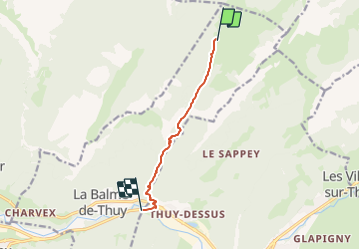
Trail Walking of 6.2 km to be discovered at Auvergne-Rhône-Alpes, Upper Savoy, La Balme-de-Thuy. This trail is proposed by COMAN.
Positioning
Country:
France
Region :
Auvergne-Rhône-Alpes
Department/Province :
Upper Savoy
Municipality :
La Balme-de-Thuy
Location:
Unknown
Start:(Dec)
Start:(UTM)
291711 ; 5090839 (32T) N.
Comments